Report by Paula Antolini
September 10, 2017 4:11PM
New Facebook Page for Hurricane Irma Where People in Florida Can Let Others Know They Are Safe and/or Offer or Request Help, And You Can Check It Too
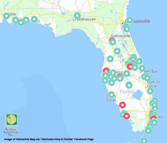
Are you worried about your relatives or friends in Florida? Do they need help? Now there is Facebook page entitled”Hurricane Irma in Florida” where you can click on “Friends in Area” to see if your relatives or friends posted a message that they are safe.
There is also an interactive map where you can view people who are requesting or offering help. So far there are 91 posts requesting help and 1,050 posts offering help.
If you need urgent help, please call your local emergency number.
*****
According to the page:
>Hurricane Irma has made landfall in the Florida Keys and is currently located in the Gulf of Mexico, approximately 210 miles south-southeast of Tampa, Florida.
Irma is moving north at nine miles per hour while exhibiting maximum sustained winds of 130 miles per hour with gusts of up to 160 miles per hour.
The storm continues to impact parts of northern Cuba, the Florida Keys as well as the southern Florida Peninsula.
Irma is expected to increase forward speed as it continues to move towards the Florida Keys and the western coast of Florida.
The hurricane is forecast to move near or along the southwest coast of the Florida Peninsula through Sunday afternoon.
The National Hurricane Center has reported that hurricane force winds are beginning to impact the Florida Keys and tropical storm conditions are beginning to impact the southern Florida.
Preemptive states of emergency have been issued for Florida, South Carolina, North Carolina, Georgia, and Virginia.
Storm surge is expected to reach the following heights above ground if peak surge occurs during high tide: -Cape Sable to Captiva: 10 15 feet – Captiva to Ana Maria Island: 6 10 feet – Card Sound Bridge through Cape Sable, including the Florida Keys:5 10 feet – Ana Maria Island to Clearwater Beach, including Tampa Bay: 5 8 feet – North Miami Beach to Card Sound Bridge, including Biscayne Bay: 3 – 5 feet – South Santee River to Fernandina Beach: 4 6 feet – Clearwater Beach to Ochlockonee River: 4 6 feet – Fernandina Beach to Jupiter Inlet: 2 4 feet – North of North Miami Beach to Jupiter Inlet: 1 2 feet
Hurricane warnings are in place for: – Fernandina Beach southward around the Florida peninsula to Indian Pass – Cuban provinces of Ciego de Avila, Sancti Spiritus, Matanzas, La Habana, and Villa Clara – The Florida Keys – Florida Bay – Lake Okeechobee Hurricane watches are in effect for: – North of Fernandina Beach to Edisto Beach Tropical storm warning is in place for: – West of Indian Pass to the Okaloosa/Walton County Line – North of Fernandina Beach to South Santee River
Tropical storm watch is in place for: -Bimini and Grand Bahama Tropical Storm Risk has issued a Red Alert for Cuba and the United States.
Red Alert has been issued for the city of Fort Myers between now and the next 9 hours, and for Tampa, Miami, and Orlando between now and the next 21 hours. A Red Alert indicates there is a 31 100 percent probability that the storm will result in maximum sustained winds of at least Category 1 strength.
Tropical Storm Risk issued a Yellow Alert for the Bahamas between now and the next 21 hours. In addition, a Yellow Alert has been issued for the cities of West Palm Beach and Freeport within the next 9 hours, Tallahassee, Savannah, Columbia, Charleston, and Nueva Gerona within the next 21 hours, Jacksonville and Atlanta within the next 33 hours, and Montgomery within the next 45 hours. A Yellow Alert indicates there is a 10-30 percent probability that the storm will result in maximum sustained winds of at least Category 1 strength, or greater than 50 percent probability that it will result in maximum sustained winds of at least tropical storm strength. NC4 has created an individual incident to cover Hurricane Irma’s damage in the Caribbean. To view Hurricane Irma’s latest impact summary, please see our Meteorological Advisory for the Caribbean region.
When:September 9, 2017
Affected Cities:
Last updated on September 10, 2017 at 11:40am
This information is provided by NC4, an independent global crisis reporting agency.
###


Leave a Reply