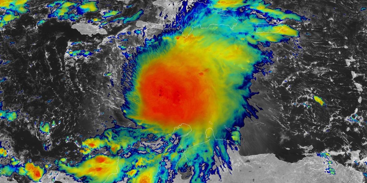
Kingston, Jamaica — Tropical Storm Melissa is slowly churning through the Caribbean Sea, bringing the threat of life-threatening floods, mudslides, and destructive winds to Jamaica, Haiti, and the Dominican Republic later this week.
As of Wednesday afternoon, the National Hurricane Center (NHC) reported that Melissa was about 300 miles southeast of Kingston with maximum sustained winds of 50 mph, moving at an extremely slow pace of 2 mph.
Forecasters warn that Melissa could become the Caribbean’s first hurricane of the 2025 Atlantic season and potentially the fourth major hurricane of the year — a Category 3 or stronger storm.
Heavy Rainfall and Flooding Threat
Rainfall from the storm is already spreading north as Melissa inches toward Jamaica and Hispaniola. Meteorologists expect 12 inches or more of rain in southern Haiti and the Dominican Republic through the weekend, heightening the risk of catastrophic flash flooding and mudslides across mountainous areas.
“That much rain over rugged terrain is a recipe for disaster,” the NHC warned. “Residents should be prepared for life-threatening floods and landslides.”
According to CNN, Melissa’s sluggish pace is compounding the danger. Slow-moving storms tend to pound the same areas for days, leading to massive rainfall totals and extended power outages.
Forecast: From Tropical Storm to Major Hurricane
Meteorologists say Melissa is moving over extremely warm Caribbean waters — conditions that can rapidly intensify tropical systems late in the season.
- Current wind speed: 50 mph
- Movement: Northwest at 2 mph
- Expected to strengthen: Hurricane status by Saturday morning
- Potential peak intensity: Category 4 by Monday
“Melissa has both the fuel and time to strengthen significantly,” meteorologists said, noting the storm could tap into “rocket fuel-level warmth” in the southern Caribbean.
If it follows its current forecast track, Melissa could intensify south of Jamaica before turning northeast next week, threatening Cuba and other parts of the Caribbean.
Two Possible Tracks, Both Dangerous
The NHC says Melissa’s exact path remains uncertain, but two primary scenarios are emerging:
- Southern Track (More Dangerous):
- Moves slowly west, staying south of Jamaica.
- Strengthens into a Category 3–4 hurricane by Monday.
- Could bring extreme rainfall, high winds, and dangerous seas to Haiti and the Dominican Republic.
- Northern Track (Closer to Land):
- Pulled north earlier toward Jamaica or Haiti.
- Could make direct landfall, producing widespread flooding but possibly limiting its ability to strengthen further.
“Both tracks put parts of Hispaniola and Jamaica at serious risk,” the NHC stated. “Even if Melissa doesn’t make landfall, its impacts will be significant.”
Potential Impact on the United States
While the risk to the U.S. mainland remains low for now, forecasters are not ruling out the possibility of indirect effects.
- Florida could experience rough surf, rip currents, and coastal flooding early next week if Melissa shifts north later than expected.
- Cuba and the Bahamas may also face heavy rain and gusty winds depending on the storm’s trajectory.
“It’s too early to dismiss a U.S. impact entirely,” forecasters said. “Late-season storms can take unexpected turns.”
Historically, hurricanes like Nicole (2022) and Zeta (2020) have struck the U.S. in late October or early November, proving the season’s end date — November 30 — doesn’t always mean an end to threats.
A Season That Refuses to Quit
Melissa’s development underscores how climate change and warmer ocean waters are fueling longer and stronger hurricane seasons. Three of this year’s four hurricanes — Erin, Gabrielle, and Humberto — underwent rapid intensification, a phenomenon that experts warn is becoming more common.
As Melissa continues to evolve, its strength, path, and potential impacts will come into sharper focus over the coming days.
What are your thoughts on the growing intensity of late-season storms? Share your views in the comments below.


