Los Angeles, CA – A slow-moving winter storm continued to drench Southern California on Friday, worsening already saturated conditions and raising serious concerns about flash flooding, debris flows, and travel disruptions across the region.
The system, fuelled by an atmospheric river over the Pacific, brought heavy rain during the early morning hours, flooding roadways and prompting multiple warnings from the National Weather Service (NWS).
Atmospheric River Delivers Heavy Morning Rain
Meteorologists with the National Weather Service said the heaviest rainfall from the first of two storm systems was expected during the morning hours as the slow-moving weather pattern stalled over Los Angeles County and surrounding areas.
Officials warned that the storm’s impacts were intensified because the region’s soil was already super-saturated from recent rainfall.
“The flooding threat created by these rains will be exacerbated due to the super saturation of the area,” the NWS stated.
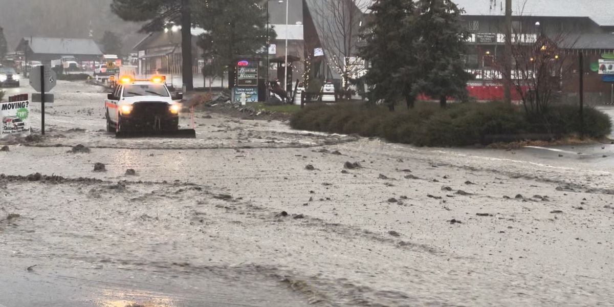
Flash Flood Warnings Issued Across Multiple Areas

As rain intensified early Friday, the NWS issued flash flood warnings for several vulnerable communities, including Hollywood, Malibu, and Topanga, with alerts remaining in effect through noon Friday. Additional flash flood warnings were also issued earlier in the morning for Ojai, Mira Monte, and Oxnard.
Forecasters predicted widespread rainfall totals of 1 to 1.5 inches in coastal and valley areas, while south-facing foothills and mountain regions could receive up to 3 inches of rain, significantly increasing the risk of runoff and mudslides.
Flooding Forces Closure of Interstate 5
One of the most significant impacts occurred in Sun Valley, where a portion of the 5 Freeway (Interstate 5) was closed due to flooding during the morning commute. According to the California Highway Patrol (CHP), all northbound lanes were shut down shortly before 7 a.m., with traffic diverted off the freeway at Tuxford Street.
Officials did not immediately provide a timeline for reopening the lanes, leaving commuters scrambling for alternate routes amid heavy rain and poor visibility.
Christmas Eve Storm Damage Still Emerging
The dangers posed by repeated storms became even clearer as damage from a Christmas Eve storm in the mountain community of Wrightwood came into focus on Thursday.
Rain-triggered mudslides buried homes and vehicles under several feet of thick mud, rocks, and debris. The storm struck a 2024 wildfire burn scar, leading to a powerful debris flow that overwhelmed roads, cabins, and infrastructure throughout the area.
Wrightwood, a community of approximately 5,000 residents, saw many residents choose to evacuate ahead of the storm. Authorities confirmed that most—but not all—residents evacuated, and despite the extensive damage, no significant injuries or deaths were reported.
Second Storm Brings Continued Rain Threat
While the first storm delivered the most intense rainfall, a second, weaker system was expected to move through Friday afternoon, keeping rain in the forecast throughout the day.
The NWS said the second system would likely bring 0.10 to 0.25 inches of rain, with some localized areas receiving up to 0.5 inches due to heavier showers.
“There will be a marked decrease in shower activity in the afternoon, and the showers will end in the evening,” forecasters said.
Snow Levels Drop as Cooler Air Arrives
In addition to rain, the storm system also affected mountain snow levels. Snow was expected to begin around 8,000 feet before dropping to approximately 6,000 feet as cooler air moved into the region later Friday.
Meteorologists forecast 1 to 2 inches of snow above 6,000 feet by late afternoon, with the possibility of snow falling as low as 5,000 feet during the evening hours.
Clearing Skies and Cooler Temperatures Ahead
Conditions are expected to improve heading into the weekend. Forecasters said skies should clear on Saturday, though cooler temperatures will settle across the region. Afternoon highs across much of the Los Angeles area are expected to struggle to reach the 60s, offering a chilly but calmer break from the relentless storms.
How has this storm impacted your area? Have you experienced flooding, road closures, or power outages? Share your experience and thoughts in the comments below—your insights can help keep others informed and prepared.


