Seattle, WA – Washington state is bracing for a high-impact storm system that is expected to bring rising rivers, strong and potentially damaging winds, and significant mountain snowfall from Tuesday night through Wednesday, forecasters warned.
The combination of heavy rain, saturated ground, and rapidly dropping snow levels is raising concerns for flooding, power outages, and dangerous travel conditions across large portions of the state.
Meteorologists say conditions will worsen as a much stronger system arrives late Tuesday, following a relatively mild and showery start to the day.
Showery Start, Then a Stronger Storm Moves In
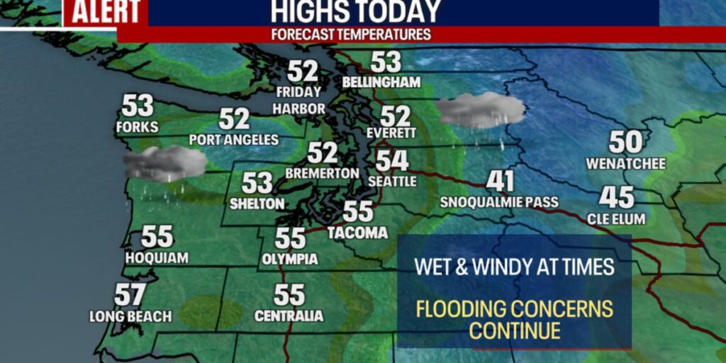
The first half of Tuesday will remain mild and unsettled, with on-and-off showers and high temperatures climbing into the mid-50s across much of western Washington. However, forecasters caution that this will be the calm before the storm.
By Tuesday afternoon, weather conditions will begin deteriorating as a powerful Pacific system pushes toward the region, setting the stage for gusty winds, heavy rainfall, and rapidly rising rivers.
Strong Winds Target Western Washington Overnight
One of the most concerning threats with this storm will be strong southerly winds, particularly across western Washington, the Puget Sound region, and the Washington Coast.
Forecasters say winds will begin ramping up Tuesday afternoon, becoming more widespread after sunset. The strongest gusts are expected between 10:00 p.m. Tuesday and 6:00 a.m. Wednesday.
- Seattle metro area: Wind gusts of 45 to 50 mph
- Coastal areas, Hood Canal, south of Seattle, and north of Everett: Gusts up to 60 mph
Because the ground is already extremely saturated, officials warn that trees could be uprooted more easily, increasing the risk of downed power lines, blocked roads, and power outages.
After Wednesday morning, winds are expected to gradually ease, though breezy conditions may persist.
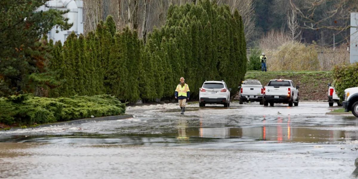
Rivers Rising Toward Flood Stage
As heavy rain continues through Tuesday and into Wednesday, rivers across western Washington are expected to rise rapidly. Forecasters say several rivers will reach flood stage, with some cresting at moderate to major flood levels by Wednesday and Thursday.
Currently, eight rivers are under flood warnings:
- Skykomish River
- Skagit River
- White River
- Green River
- Cedar River
- Cowlitz River
- Skokomish River
- Stehekin River
The Skagit River is the only river currently expected to crest at major flood stage, making it a primary concern for emergency managers.
Additionally, the Snohomish River is forecast to reach moderate flood stage, though it is not yet under a flood warning.
Residents living near rivers and flood-prone areas are urged to closely monitor conditions, prepare for possible evacuations, and avoid flooded roadways.
Heavy Mountain Snow Creates Dangerous Travel Conditions
While lowland areas deal with rain, the mountains will see a dramatic shift to heavy snow late Tuesday night into Wednesday as snow levels drop quickly.
Forecast snowfall totals include:
- Snoqualmie Pass: 10+ inches by Wednesday afternoon
- Stevens Pass and White Pass: 18 to 24 inches possible
Travel over the mountain passes will be very difficult, if not dangerous, due to heavy snowfall, reduced visibility, and slick road conditions. Drivers are urged to delay travel if possible, carry chains, and check road conditions before heading out.
Brief Break Before More Rain and Snow Return
Forecasters say Friday and Saturday should bring a temporary break from widespread rain, with only a few isolated showers possible on Saturday.
However, the quiet weather will be short-lived. More lowland rain and mountain snow are expected to return early next week, along with cooler temperatures, continuing the active weather pattern.
Stay Prepared and Stay Informed
With damaging winds, flooding rivers, and heavy mountain snow all in play, emergency officials urge residents to take this storm seriously. Secure loose outdoor items, avoid unnecessary travel during peak storm hours, and keep emergency supplies on hand in case of power outages.
Have you been affected by flooding, wind damage, or mountain travel issues during storms like this? How are you preparing for the latest system moving through Washington?
Share your experience, photos, and safety tips in the comments below and join the conversation.


