Green Bay, Wisconsin – Weather conditions across northeast Wisconsin are setting up for a busy and impactful stretch, with fluctuating temperatures, changing precipitation types, and a potential flash freeze as the region heads deeper into December. Residents should prepare for everything from gusty winds and cold nights to rain, snow, and rapidly dropping temperatures over the next several days.
Cloudy and Breezy Start Tonight
Tonight begins on a cloudy and breezy note, with a southwest wind gusting up to 25 mph across much of the region. Temperatures will hold relatively steady in the mid-30s through the evening hours. However, conditions will change overnight as clouds gradually clear and winds begin to ease.
As skies open up, colder air will settle in, allowing temperatures to drop sharply into the low to mid-20s by daybreak. Drivers heading out early Wednesday morning should be aware of the potential for patchy icy spots, especially on untreated roads and bridges.
Wednesday Brings a “December Gem”
Wednesday is shaping up to be a true December gem for northeast Wisconsin. Expect mostly sunny skies, light winds under 15 mph, and seasonable high temperatures ranging from the upper 20s to the low 30s.
While a few clouds may drift in later in the afternoon, overall conditions will be pleasant and calm, making Wednesday the best day of the week for outdoor plans, errands, or travel before the next weather system arrives.
Rain Returns Thursday Morning
Temperatures will moderate Wednesday night, setting the stage for the next system. Rain showers are expected Thursday morning, moving into the area as warmer air surges northward ahead of a strong front.
Forecasters expect a brief lull in precipitation around midday Thursday, offering a short break before conditions turn more complicated later in the day.
Rain-to-Snow Mix and Flash Freeze Concern Thursday Night
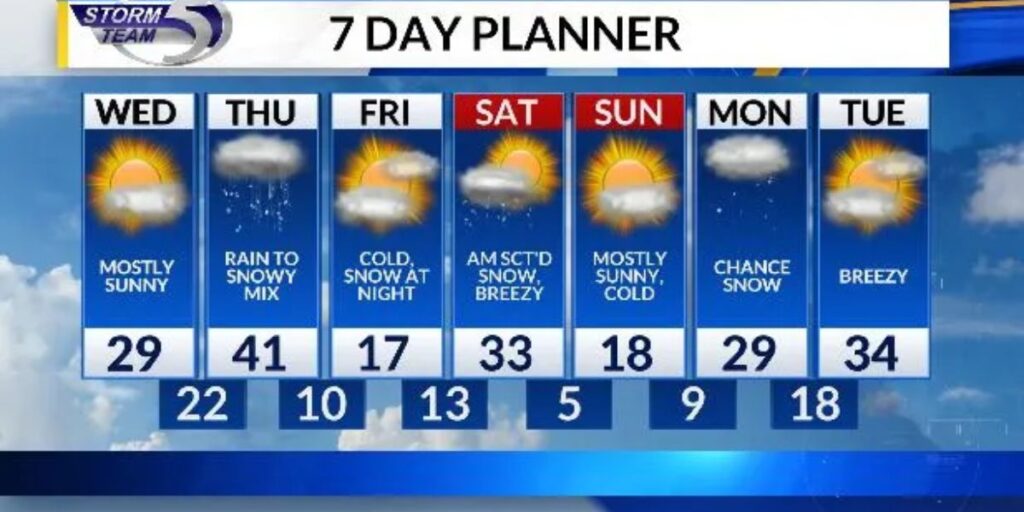
By Thursday evening and night, colder air will begin pushing back into the region. This will likely cause precipitation to transition into a snowy mix, with rain changing to snow in some areas.
High temperatures Thursday will reach the low 40s, driven by a strong southerly wind pulling in unseasonably mild air. However, once winds shift to the northwest, temperatures will plummet rapidly Thursday night.
This sharp temperature drop raises concerns for a flash freeze, where wet roads and surfaces freeze quickly, creating dangerous travel conditions overnight and into early Friday.
Much Colder Weather Arrives Friday
Friday will feel like a dramatic reset. Expect a mix of sunshine and clouds, but temperatures will struggle to recover, with highs only reaching the upper teens.
Cold conditions will persist into Friday night as snow showers move into the region, continuing into the early morning hours of Saturday.
Accumulating Snow Possible This Weekend
The system moving in Friday night could bring several inches of snow, especially for northern parts of northeast Wisconsin. While exact totals are still uncertain, residents should prepare for snow-covered roads, reduced visibility, and slick conditions heading into the weekend.
Looking Ahead to Christmas Week
Looking further ahead, milder air is expected to return for Christmas week. While this may bring some relief from the bitter cold, forecasters are watching closely to ensure temperatures do not rise enough to significantly reduce the existing snowpack, which many hope sticks around for a white Christmas feel.
Stay Weather-Aware
With rapid temperature swings, changing precipitation, and the risk of a flash freeze, staying informed will be critical over the next several days. Make sure vehicles are winter-ready, allow extra travel time, and keep an eye on updated forecasts.
What are your thoughts on this upcoming rain-to-snow pattern and the chance of a flash freeze? Are you hoping for more snow or warmer temperatures heading into Christmas week? Share your thoughts in the comments below and join the conversation.


