Honolulu, HI – A state of emergency remains active across Hawaii as Hurricane Kiko barrels westward across the Central Pacific Ocean, threatening to bring massive waves, rip currents, and heavy rain to the Aloha State this week.
The storm, once a major hurricane, has prompted statewide emergency measures in preparation for its close pass north of the islands.
Although now downgraded to a Category 2 hurricane, Kiko still packs sustained winds near 110 mph and has the potential to trigger life-threatening surf conditions as it nears Hawaii’s shores. Officials and forecasters are urging residents to remain vigilant as hazardous ocean conditions are expected to impact the region starting as early as Sunday.
State of Emergency and Preparedness Measures
Hawaii’s Acting Governor Sylvia Luke declared a statewide state of emergency over the weekend in response to Kiko’s threat, mobilizing state agencies and the Hawaii National Guard to ensure readiness for rapid response. Governor Luke emphasized the importance of preparedness, stating:
“To ensure the safety and preparedness of our communities, the state and counties will stand ready to mobilize resources to clear debris, secure infrastructure, and respond quickly to any possible damage caused by the storm.”
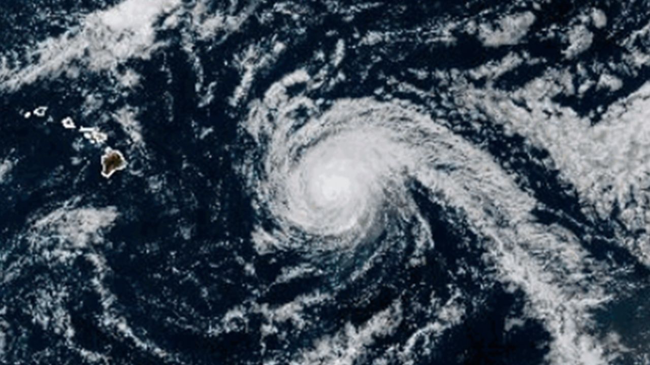
- Kiko’s location: Approximately 635 miles east of Hilo and 900 miles east-southeast of Honolulu as of the latest National Hurricane Center (NHC) advisory.
- Moving west-northwest at 13 mph with sustained winds near 110 mph.
- Expected to pass just north of the Hawaiian Islands around Tuesday and Wednesday.
- Life-threatening surf and rip currents expected to impact the Big Island and Maui beginning Sunday.
Forecast and Storm Behavior
Despite Kiko’s weakening trend, the storm remains a serious concern due to the dangerous surf it generates. The NHC warns that large swells will build and peak along east-facing coasts of the islands by late Monday through midweek, increasing the risk of hazardous ocean conditions.
Experts note several factors are contributing to Kiko’s weakening as it approaches Hawaii:
- Sea-surface temperatures in the mid-70s near the islands, cooler than the typical waters needed to sustain a strong tropical cyclone.
- Increasingly hostile upper-level winds and drier air working to sap the storm’s strength.
- The storm’s relatively small size, with hurricane-force winds extending only about 25 miles from the center and tropical-storm-force winds reaching up to 80 miles.
According to FOX Weather Hurricane Specialist Bryan Norcross,
“Because the circulation is small, and even the Big Island is a relative speck in the vastness of the ocean, a slight deviation in Kiko’s track will make a dramatic difference in the weather that impacts Hawaii. We won’t really have a good idea about that until the storm gets closer, but right now, the consensus is that Kiko’s center will pass just north of the islands with most of the moisture and wind offshore.”
Forecasters expect that Kiko will weaken to a minimal hurricane by Monday night and further downgrade to a tropical storm by Tuesday morning as it nears the islands.
Potential Impact on Hawaii Beaches and Communities
While the likelihood of direct landfall is very low, residents should prepare for the powerful rip currents and large surf that could threaten beachgoers and coastal areas. Heavy rainfall is also possible if the storm passes close enough, which could lead to localized flooding concerns.
- Swells affecting Big Island and Maui as early as Sunday.
- Peak surf on east-facing shores expected from late Monday through midweek.
- Residents urged to avoid swimming or entering the ocean during dangerous conditions.
For more detailed updates, residents and visitors can follow the National Hurricane Center advisories and local emergency management instructions.
Staying Safe and Prepared as Hurricane Kiko Approaches
Officials encourage all Hawaii residents to monitor local weather reports closely and adhere to any directives issued by emergency management. Preparation steps include securing outdoor items, planning for possible power outages, and staying clear of hazardous coastal waters.
- Stay informed through trusted weather authorities.
- Avoid unnecessary travel or outdoor activities near the shore during the peak of hazardous conditions.
- Have emergency supplies and plans ready in case conditions worsen.
By taking these precautions seriously, communities can reduce risks and enhance safety as Hurricane Kiko approaches.
What do you think about the approaching Hurricane Kiko? Are you prepared for the high surf and rip currents expected in Hawaii? Share your thoughts and experiences in the comments below!


