Houston, TX – Houston experienced its first cold snap of the season early Monday, with feels-like temperatures plunging into the 20s and 30s across Southeast Texas. Residents woke up to brisk northern winds and a noticeable chill, marking the official start of sweater weather in the region.
Meteorologists advised locals to bundle up with jackets, sweaters, and even beanies, as the wind chill made the morning feel significantly colder than the thermometer readings.
Freeze Warning Issued for Northern Counties
The coldest air settled north of Harris County, where Polk, Walker, Trinity, and Madison counties were placed under a Freeze Warning until 9 a.m. Monday. Temperatures in these areas dipped well below freezing, prompting residents to protect plants, pets, and outdoor plumbing.
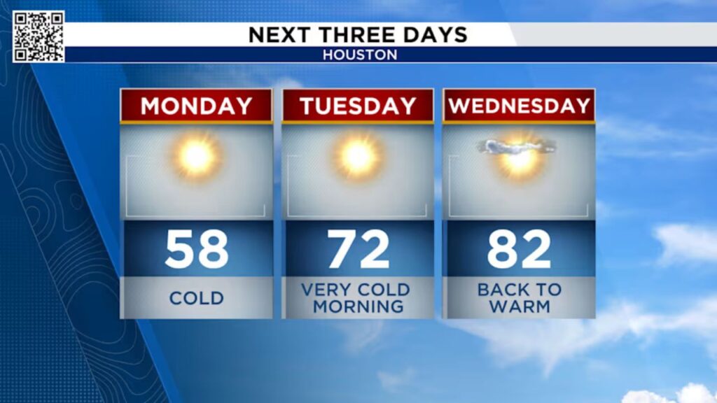
By Monday afternoon, temperatures were expected to climb only into the 50s and 60s, with winds gradually easing throughout the day.
Fire Danger Rises Amid Dry Conditions
While the chilly air brought relief from humidity, it also increased fire danger across the region. The National Weather Service (NWS) issued a Red Flag Warning for all of Southeast Texas through Monday evening, cautioning residents about high wildfire risks.
Meteorologists explained that the strong winds have been drying out the atmosphere, stripping away what little moisture remains. As a result, the region is left vulnerable to fast-spreading fires if sparks occur.
As of Thursday, more than 80% of Southeast Texas remains under drought conditions, with some western counties experiencing extreme drought. Fire officials are urging everyone to avoid outdoor burning, discard cigarettes responsibly, and secure trailer chains that could create sparks on roadways.
Tuesday Brings More Cold Mornings, Then a Warm-Up
The cold air mass will continue to grip Southeast Texas into Tuesday morning, keeping temperatures in the 30s before a noticeable warm-up later in the day. By Tuesday afternoon, highs will reach the upper 60s to low 70s, giving residents a brief taste of mild fall weather.
This cold blast, however, won’t last long. Forecasters predict that by midweek, temperatures will rebound to near 80 degrees, marking a quick return to Houston’s signature warmth.
Extended Forecast: Drought Persists, Rain Unlikely
Unfortunately, rain chances remain minimal through the week. Meteorologists expect that precipitation won’t return until next weekend, and even then, it won’t be enough to ease the ongoing drought in Southeast Texas.
With dry, windy conditions and little rainfall, the threat of wildfires and poor air quality will likely continue into the coming days.
Stay Weather Aware
Residents are encouraged to monitor local forecasts, limit outdoor burning, and take precautions against both the cold and the fire risk. Pets, elderly individuals, and those without adequate heating should be checked on during the overnight chill.
How are you preparing for Houston’s first big cold snap?
Are you more concerned about the freezing temperatures or the fire danger across Southeast Texas?
Share your thoughts and local experiences in the comments below!


