Indianapolis, IN – Winter is making its presence known across central Indiana, as a fast-starting snow season intensifies with heavy snowfall, dangerous cold, and life-threatening wind chills expected this weekend. Meteorologists warn that travel conditions could quickly deteriorate, especially on Saturday afternoon, when snow rates increase and visibility drops.
Snowfall Surpasses Seasonal Averages Across Central Indiana
Over the past 24 hours, 1 to 5 inches of snow has fallen across central Indiana, with the heaviest totals south of Interstate 70. By comparison, Indianapolis typically averages 2.7 inches of snow by this point in the season. This year, however, the city has already recorded 9.3 inches, marking the fastest start to the snow season since 1989.
Forecasters say the active winter pattern is far from over, with another impactful system arriving just in time for the weekend.
Winter Weather Advisory Issued for Saturday
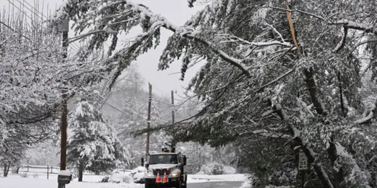
The National Weather Service has issued a Winter Weather Advisory for much of central Indiana, in effect from 11 a.m. Saturday until midnight. Snow is expected to begin Saturday morning and continue through much of the day as snow showers become more widespread.
Unlike Friday’s weaker system, this storm is tracking farther north, increasing the likelihood of heavier snowfall across the region. Meteorologists say snow will become heavy at times Saturday afternoon, creating hazardous driving conditions.
Officials strongly urge residents to avoid unnecessary travel, especially during peak snowfall periods, as visibility will be significantly reduced.
Several Inches of Snow Expected Before Evening
Snow accumulation is expected to add up quickly. Forecasts indicate 3 to 5 inches of snow, with some areas potentially seeing 4 to 6 inches by the time snow tapers off Saturday evening.
- Saturday highs: Low to mid-20s
- Snowfall totals: 3″ to 6″ possible
- Heaviest snow: Saturday afternoon
Road crews are preparing for challenging conditions, but drivers should plan for slick roads, snow-covered highways, and delays throughout the day.
Dangerous Cold Follows Snowfall Saturday Night
As snow winds down Saturday evening, a surge of Arctic air will move in rapidly. Overnight lows are forecast to fall below 0°, setting the stage for dangerously cold conditions.
A Cold Weather Advisory will be in effect Sunday morning, as wind chill values plunge to 20 degrees below zero in some locations. Exposure to these conditions can lead to frostbite in minutes, prompting officials to urge residents to limit time outdoors and ensure proper winter protection.
Sunday Brings Bitter Cold but Dry Conditions
While snow will be out of the forecast on Sunday, the cold will remain extreme. High temperatures are expected to struggle to climb out of the single digits, making it one of the coldest days so far this season.
- Sunday highs: Single digits
- Wind chills: As low as -20°
- Conditions: Dry but dangerously cold
Residents are encouraged to check on elderly neighbors, protect pets, and prevent frozen pipes during the cold snap.
Warmer Air Arrives Next Week
After a frigid weekend, relief is finally on the horizon. A warming trend begins early next week:
- Monday: Highs in the 20s
- Tuesday: Temperatures rise above freezing
- Wednesday: Highs warm into the 40s
Meteorologists say the warming trend will be noticeable, especially after days of subzero wind chills.
Rain Possible by Thursday as Temperatures Surge
By Thursday, another storm system is expected to move into the region. With temperatures potentially climbing into the 50s, precipitation will likely fall as rain instead of snow. This could lead to melting snow, wet roadways, and localized water issues.
Forecasters note that the rapid transition from heavy snow to rain is another sign of how dynamic this winter pattern has become.
Winter Off to a Historic Start
With heavy snow likely Saturday, advisories in effect, and extreme cold to follow, meteorologists emphasize that Indiana’s winter season is off to an unusually fast and intense start. Residents are urged to stay weather-aware, follow travel advisories, and prepare for rapidly changing conditions.
How much snow have you seen where you live, and are you ready for the bitter cold and subzero wind chills? Share your snowfall totals, travel plans, and winter prep tips in the comments, and let us know how this storm is impacting central Indiana.


