
Green Bay, Wisconsin – Residents of Green Bay can expect slightly warmer temperatures tonight as a weak disturbance moves north of the area, though a brief snow shower or flurry is possible in northern parts of the region. Accumulations are expected to remain minor, and overnight lows will settle around 10 degrees by tomorrow morning.
Monday: Mostly Cloudy with Slightly Warmer Temperatures
To start the workweek, Monday will bring mostly cloudy skies across Green Bay, with periods of sunshine breaking through later in the day. Highs are expected to reach the upper teens to low 20s, slightly warmer than the previous days. Residents should be aware of breezy conditions, with winds between 10-20 mph, which may make it feel colder than the actual air temperature.
Tuesday Brings Mild Warming and Chance of Light Rain
On Tuesday, skies will remain mostly cloudy, but temperatures will rise into the low to mid-30s, offering a noticeable break from the colder start to the week. A chance of light rain showers is expected in the afternoon and evening, particularly in areas where temperatures approach the mid-30s.
Wednesday Cools Down with Strong Winds
By Wednesday, temperatures will cool to around 30 degrees for a high, under mostly sunny skies. While the sunshine will provide a brief reprieve from cloud cover, residents should prepare for sharp winds later in the day, which could make it feel significantly colder.
Thursday: Rain and Snow Mix with Temperatures in the Upper 30s
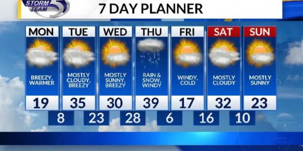
A new storm system is expected to move into the region overnight Wednesday into Thursday, bringing a mix of rain and snow. High temperatures Thursday afternoon will reach the upper 30s, but a sharp temperature drop overnight will accompany the precipitation, creating potentially slick conditions on roads and sidewalks.
Friday: Cold Temperatures Return
Following Thursday’s storm, Friday will bring a return to colder temperatures, with highs dropping into the teens to around 20 degrees. Residents should plan accordingly for frigid air and gusty winds, particularly for outdoor activities and morning commutes.
Summary
Green Bay’s weather for the week features minor snow tonight, a slight warming trend Monday and Tuesday, followed by a rain-snow mix midweek, and a return to colder temperatures by Friday. While early-week highs will offer some relief from the frigid weekend, the combination of gusty winds and fluctuating temperatures will require residents to dress in layers and exercise caution outdoors.
Will you adjust your commute or outdoor plans for the mix of snow, rain, and cold? Share your experiences and tips in the comments below.


