
Los Angeles, CA — Southern California is gearing up for a soaking as a powerful multi-day atmospheric river pushes across the region, bringing widespread rain, potential flooding, and a dramatic jump in precipitation totals. Meteorologists say the storm will unfold in two major waves, hitting communities from the Mexico border all the way to the Central Coast.
The first surge of rain kicked off early Friday morning, continuing through the day before a brief lull. The second, more robust round is expected to sweep in on Saturday morning and last into Saturday afternoon, delivering the heaviest rainfall of the entire event.
“If you’re not getting any rain now, just wait for it. You will,” said KTLA weather anchor Mark Kriski on Friday morning, summing up the system’s reach and intensity.
Downtown LA Could See a Quarter of Its Annual Rainfall
If storm totals match current forecasts, downtown Los Angeles could rack up nearly 25% of its yearly average rainfall in just a few days — a dramatic influx for a region known for long dry spells.
Weather officials warn that the combination of persistent showers, saturated soils, and bursts of intense rain may lead to flooding in both urban and rural areas.
Flood Watches Issued Across Southern California
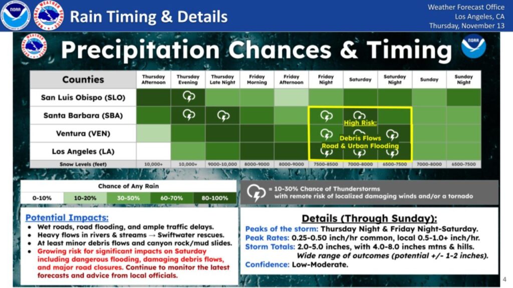
The National Weather Service (NWS) has rolled out flood watches and advisories covering a vast swath of Southern California. Alerts stretch across:
- The Mexico border
- Orange County
- Los Angeles County
- The Inland Empire
- Desert communities
- Portions of the Central Coast
Forecasters say residents should be prepared for slick roads, rapid ponding, swollen creeks, and possible mudslides in burn scar zones.
How Much Rain Will Southern California Get?
According to updated projections from the National Weather Service, most areas across the region are expected to see 3 to 6 inches of rain by the time storms taper off Saturday afternoon.
Here’s a closer look at expected totals:
Coastal Slopes
Rainfall totals on the region’s coastal mountain slopes are likely to be among the highest, potentially reaching 3 to 4 inches or more from both storms combined.
Coastal Valleys and Flatlands
Areas south of Point Conception — including valley and coastal communities in Ventura County and Los Angeles County — are projected to receive 3 to 4.5 inches between both systems.
The second storm alone is expected to bring 2 to 3 inches.
Santa Barbara South Coast
This region is already leading in rainfall. The first storm dumped 1 to more than 4 inches, and forecasters say additional rainfall is coming with Saturday’s stronger system.
Northern & Interior Sections
Communities north of Point Conception and farther inland will likely see lower totals, around 1 to 1.5 inches during the second round.
Rainfall Rates and Flooding Risk
The NWS warns that the most dangerous periods will be during intense downpours, where rainfall rates might hit 1 inch per hour, quickly overwhelming drainage systems and triggering flash flooding.
What Is an Atmospheric River?
An atmospheric river is a long, narrow corridor in the sky that transports huge amounts of moisture from the tropics toward land. When that moisture condenses over mountains and coastlines, it can rapidly unleash heavy, sustained rainfall — exactly what Southern California is bracing for this weekend.
Are these powerful atmospheric river storms becoming the new normal for Southern California — or just part of seasonal weather cycles?
Share your thoughts in the comments and tell us how you’re preparing.


