
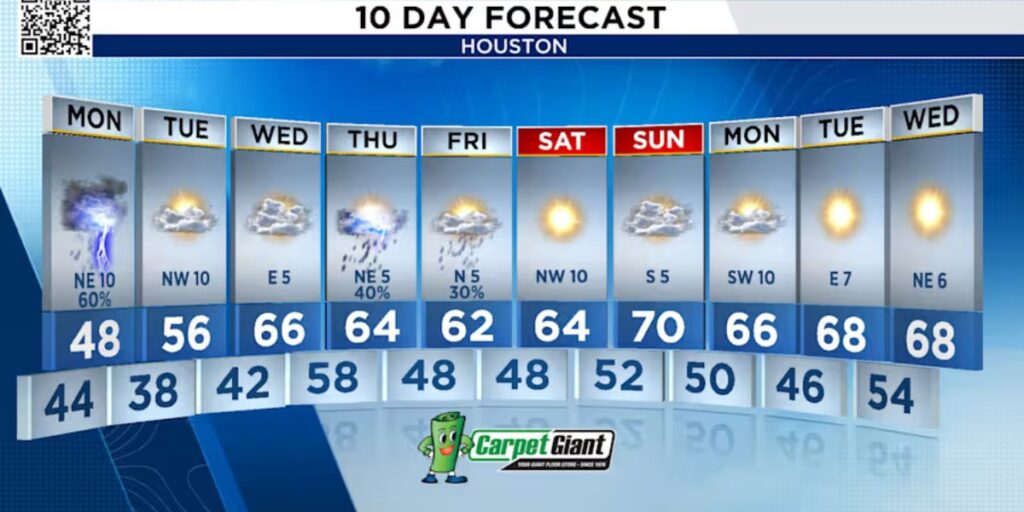
Houston, Texas — A raw and rainy Monday is setting up across the Houston area as a pair of storm waves moves inland from the south. According to forecasters, the first band of steady rain will arrive before sunrise, spreading from the coast northward toward I-10, affecting early commuters and dampening the start of the workweek.
By the end of the morning commute, most communities will catch a brief break as the initial wave shifts eastward. Roads, however, are expected to stay wet and slick, with reduced visibility lingering behind the first round of showers.
Second Wave Hits Midday, Extending Through Evening
Around 12 PM, another more persistent wave of rain is forecast to move across the region. This second round is expected to last throughout the afternoon and into the evening hours, with steady rainfall creating challenges for drivers heading home from work or school.
The steady rain will taper off after 5 PM for most inland neighborhoods, but areas closer to the coast may see lingering light rain into the early evening. Forecasters say stray showers could continue to pop up until midnight, keeping conditions damp long after sunset.
Low Flood Threat, Mainly Near I-10 and the Coast
Despite the multiple rounds of rainfall, meteorologists describe the flood risk as low. Still, there is potential for street flooding and ponding, particularly in areas between I-10 and the coast, where rain rates may briefly intensify and drainage can be slower.
Drivers are urged to use caution throughout the day—especially in low-lying neighborhoods, busy intersections, and poorly lit evening roadways.
Cold Temperatures Add to the Raw Conditions
Alongside the rain, temperatures will remain chilly from morning through evening. Residents will start the day waking up to the low to mid-40s, with afternoon highs struggling to reach the 50s, making for a damp and uncomfortable day outdoors.
Wind chills will add an extra bite, making the air feel colder than the thermometer suggests. Meteorologists recommend dressing in layers, wearing waterproof outerwear, and limiting extended time outdoors as the raw conditions persist.
Mild Warm-Up Expected by Midweek
Relief is on the horizon. The chilly, unsettled weather pattern is expected to ease by Wednesday, with temperatures beginning to return to seasonal averages. Sunshine may gradually increase later in the week, offering a break from the cold, wet start to December.
Until then, residents should keep umbrellas handy, plan for slower travel times, and stay mindful of changing road conditions as multiple waves of rain pass through the region.
Join the Conversation
How are you handling this cold, rainy Monday across Houston? Share your weather updates, commute experiences, or tips for staying warm and dry in the comments below!


