
Cleveland, Ohio — Residents across Cleveland are looking at a calm but brisk night as mostly cloudy skies linger over the region. Even though tonight won’t be quite as cold as earlier in the week, temperatures will still dip into the 30s, leaving most neighborhoods waking up to readings in the mid-30s by early Thursday morning.
Meteorologists say the atmosphere remains stable, meaning no precipitation or major weather disturbances are expected overnight.
This marks a slight improvement from the earlier cold snap, but you’ll still want a jacket if you’re stepping out late tonight or heading out early in the morning.
Temperatures Return to Normal by Week’s End
The bigger weather shift arrives as we move toward the end of the week. After several days of below-average readings, temperatures are expected to bounce back toward what’s considered seasonable for November. Afternoon highs on Thursday will climb into the upper 40s and low 50s, giving Clevelanders a small but welcome warm-up.
Skies on Thursday will stay mostly cloudy, but forecasters note a chance for a few breaks of sunshine during the day. Even with the filtered sun, the overall weather pattern remains calm — no storms, snow, or strong winds expected.
Rain System Approaches Late Friday
The next notable change arrives Friday, when a slow-moving weather system brings pockets of rain to the southern half of Northeast Ohio. This incoming moisture is expected to roll in late Friday evening and continue into the overnight hours.
Rainfall totals will stay on the lighter side, with forecasters predicting less than 0.25 inches across affected areas. The showers will be spotty, meaning some neighborhoods may see noticeable rainfall while others get barely anything.
The shower risk wraps up by around 7 a.m. Saturday, allowing the weekend to start on a relatively dry note.
Warm Front Gives the Area a Brief Mild Stretch
After beginning the week far below normal, a stalled warm front will usher in a stretch of mild weather across Northeast Ohio. This pattern may push temperatures into the 50s, and parts of the southern counties could briefly hit near-60 degrees, offering a short-lived reminder of early fall.
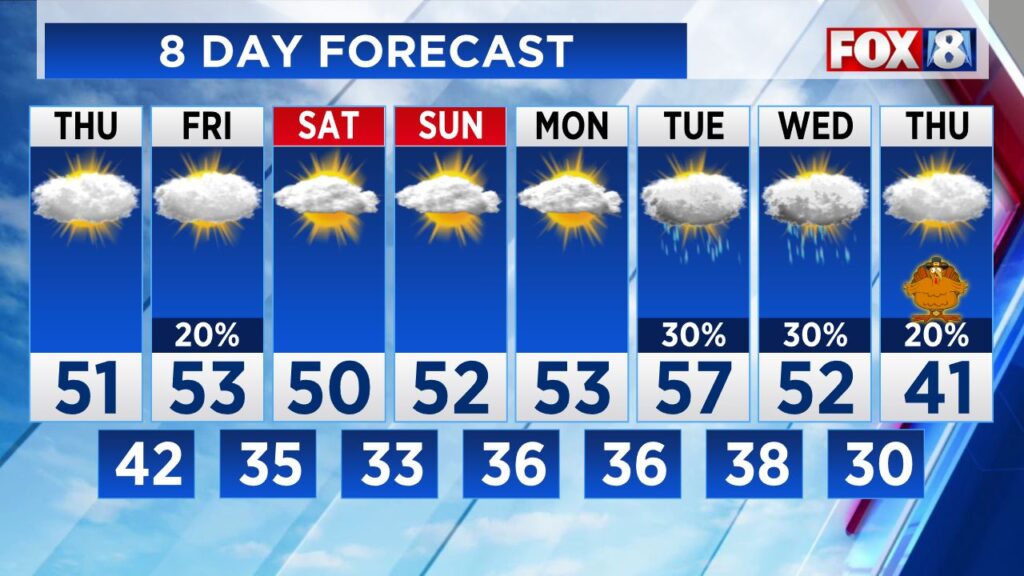
According to long-range insights from meteorologist Scott, issued back on November 11, this milder pattern is expected to carry through Wednesday of next week. This trend will give residents several days of comfortable temperatures before a dramatic shift later in the month.
Major Cold Snap Expected for Thanksgiving
Enjoy the mild stretch while it lasts — because a serious blast of cold air is waiting right around the corner. Forecast models are lining up for a significant temperature drop heading into Thanksgiving and the following weekend.
Meteorologists are warning that this incoming cold air mass will be much colder than anything the region hasexperienced so far this month.
Are you ready for the quick warm-up — or already bracing for that Thanksgiving cold plunge? Share your weather predictions, plans, or local observations in the comments!


