Report by Paula Antolini
March 21, 2018 5:00AM EDT
Bethel Public Schools are on an Early Dismissal Schedule, Wednesday, March 21th, Due to Impending Storm, 12 to
18+ Inches of Snow Expected
Message from Bethel Public Schools:
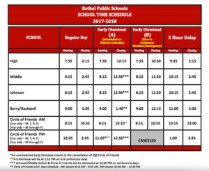
BPS on Early Dismissal Schedule B Today, Wednesday, March 21, 2018.
Dismissal Times
BHS 10:50
BMS/JS 11:20
Berry/Rockwell 12:15
COF AM – 10:55
COF PM – Canceled
March 21 Update for All BHS Students and Parents:
Due to the emergency dismissal time at 10:50, we will not be administering the PSAT or SAT today. The new testing date is April 24th.
For today, all 6 periods will meet for approximately 30 minutes each. Today is a D-Day.
The Schedule is attached (below).
All students (including seniors) are required to be in school until the dismissal time of 10:50am.
Emergency Early dismissal Schedule.pdf
Or view schedule below:
Early Dismissal Schedule@10:50am
Block 1: 7:35—8:04
Block 2: 8:08—8:37
Block 3: 8:41—9:10
Block 4: 9:14—9:43
Block 5: 9:47—10:16
Block 6: 10:20—10:50
*****
NATIONAL WEATHER SERVICE
Winter Storm Warning
THURSDAY…*
18 inches are expected, with locally higher amounts possible.*
southern Connecticut, and the New York City metropolitan area in
southeast New York.*
afternoon and into the evening. Expect significant reductions in
visibility at times. A combination of the heavy snow and
occasional wind gusts up to 40 mph could bring down tree limbs
and power lines, creating power outages. Travel will be very
difficult to impossible, especially during the evening commute.
conditions will make travel very hazardous or impossible. If you
must travel, keep an extra flashlight, food and water in your
vehicle in case of an emergency. Check local Department of
Transportation information services for the latest road conditions.
-
DuringStay indoors during the storm.Prolonged exposure to cold can cause hypothermia.Walk and drive carefully on icy sidewalks and roads.Many injuries and accidents are caused by slippery conditions.Before driving, let someone know your destination, route, and expected time of arrival.If your car gets stuck, it’ll be easier to find you.If you lose feeling and color in your nose, ears, hands, or feet, cover the exposed area, avoid rubbing your skin, and seek medical help immediately.You may have frostbite.When shoveling snow, take breaks and lift lighter loads.Working too hard can lead to heart attacks.Stay dry.Wet clothes make you lose body heat, increasing your risk of hypothermia.
*****
What is a Winter Storm Warning?
*****
Detailed Forecast
Today
Snow, mainly after 8am. The snow could be heavy at times. High near 33. Wind chill values between 20 and 25. Northeast wind 11 to 17 mph, with gusts as high as 28 mph. Chance of precipitation is 100%. Total daytime snow accumulation of 3 to 5 inches possible.
Tonight
Snow, mainly before 4am. The snow could be heavy at times. Low around 30. Wind chill values between 20 and 25. Blustery, with a north wind 17 to 20 mph. Chance of precipitation is 100%. New snow accumulation of 4 to 8 inches possible.
Thursday
A 20 percent chance of snow before 11am. Mostly cloudy, with a high near 43. Wind chill values between 20 and 30. North wind 13 to 15 mph.
Thursday Night
Mostly cloudy, with a low around 26. Northwest wind 6 to 10 mph.
Friday
A 20 percent chance of snow showers after 1pm. Partly sunny, with a high near 41. Northwest wind 6 to 9 mph.
Friday Night
Mostly cloudy, with a low around 25.
Saturday
Mostly sunny, with a high near 41.
Saturday Night
Mostly cloudy, with a low around 27.
Sunday
Partly sunny, with a high near 40.
Sunday Night
Partly cloudy, with a low around 26.
Monday
Mostly sunny, with a high near 42.
Monday Night
Partly cloudy, with a low around 27.
Tuesday
Mostly sunny, with a high near 45.


Leave a Reply