Report by Paula Antolini
October 30, 2017 5:15AM EDT
UPDATE: October 30, 2017, 6:41AM EDT:
Bethel Public Schools are CLOSED Today, Oct. 30th, Due to Downed Wires/Trees.
The BPS are now closed today, Mon., Oct. 30th. Due to downed wires/trees.
*****
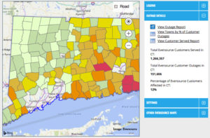
Eversource reports customers without power: Bethel 1691 (of 8,515/20%), Danbury has 1114 (of 36,260/3%), Newtown 916 (of 11,170/8%), Redding 371 (of 3,886/10%), Ridgefield 3204 (of 10,767/30%).
View Eversource Outage Map below (click on image to view larger):
From Bethel Emergency Management & Fire Marshal:
Road Closures as of 3:45am 10/30/17 …
South St from Nashville to Depot Pl. CLOSED- multiple poles & wires down
84 Hoyts Hill Rd- CLOSED btwn Governors & Fawn Rd Tree & wires down
70 Wolfpits Rd- CLOSED btwn Sunset Hill & Codfish HIll wires down
Linda La @ Taylor Rd- CLOSED- tree on wires road blocked
Area of 35 Rockwell Rd- CLOSED btwn Plumtrees & Rte 302- wires down
Plumtrees Rd btwn BPD & Maple Ave Ext (house service wire across road)
200 Old Halweyville Rd @ Clearview Ave- tree & wires down (Eversource on scene @ 2am)
Codfish Hill Rd @ Rte 302- CLOSED tree across road
Katrina Circle- one lane open but passable- large tree down
*****
NATIONAL WEATHER SERVICE 7-DAY WEATHER FORECAST for BETHEL CT:
Hazardous Weather Outlook/ Wind Advisory:
WIND ADVISORY IN EFFECT UNTIL 2 PM EDT THIS AFTERNOON…
…HIGH WIND WARNING IS CANCELLED
Flood Warning:
The Flood Warning continues for
The Still River At Brookfield.
* Until further notice.
* At 4 AM Monday the stage was 12.3 feet.
* Flood stage is 12.0 feet.
* Minor flooding is occurring and Moderate flooding is forecast.
* The river is forecast to continue rising to near 15.0 feet by 7 AM
Monday …Then begin falling.
* Impact…At 16.0 feet…Water gets into some buildings near the
river. Many roads closed and parking lots flooded
* Winds…West 15 to 25 mph with gusts up to 50 mph.
* Timing…This morning into early afternoon.
* Impacts…Strong winds may blow down limbs, trees, and power
lines. Scattered power outages are expected.
PRECAUTIONARY/PREPAREDNESS ACTIONS…
A Wind Advisory is issued when sustained winds of 31 to 39 mph,
or gusts of 46 to 57 mph, are expected or occurring. Winds this
strong can make driving difficult, especially for high profile
vehicles, in open areas, and on elevated roads and bridges. Use
extra caution.
A Wind Advisory is issued when sustained winds of 31 to 39 mph…
or gusts of 46 to 57 mph…are expected or occurring. Winds this
strong can make driving difficult…especially for high profile
vehicles. Use extra caution.
*****
*****
Original message:
Bethel Public Schools are on a 2-Hour Delay This Morning, Oct. 5
Today, Monday, October 30th, the BPS are on a 2-hour delay due to downed wires and storm debris. The Superintendent will reevaluate the situation
and a message will go out again by 7 AM.
###


Leave a Reply