
Pierre, SD – A fast-moving storm system is forecast to sweep from the Plains to the Appalachians starting Monday night, bringing snow, a wintry mix, and potential severe thunderstorms across a wide portion of the U.S., meteorologists say.
Winter Weather Set to Affect Midwest
The storm will emerge from the Rockies onto the Plains on Monday, drawing moisture from the Gulf of Mexico to fuel widespread rain across central Plains states. As this moisture collides with colder air, snow and wintry precipitation are expected to develop in South Dakota and southern Minnesota.
According to AccuWeather Meteorologist Brandon Buckingham, “Between Monday night and Tuesday morning, a slushy coating to a few inches of snow is possible across southern Minnesota, Wisconsin, southern Michigan, and northwestern Ohio.”
Most of the snow accumulation is expected on non-paved or elevated surfaces, but even a light dusting could lead to airport delays and slippery conditions on bridges and overpasses.
Minneapolis and St. Paul may experience a wintry mix, while areas just south and west of the metro could see 1–2 inches of slush. Downtown Chicago is expected to see mostly rain, with a brief wintry mix possible in northwestern suburbs. Around Detroit, western and southern suburbs are expected to receive the heaviest slushy accumulation.
Travel Hazards and Safety
Temperatures across the storm corridor are forecast to hover near freezing, meaning that major interstates and primary roads will likely remain wet, but bridges, overpasses, and higher elevations may become slippery.
As the storm progresses east-southeast, portions of Pennsylvania, western Maryland, northern West Virginia, and northern New Jersey may experience minor snow accumulation. The central Appalachians could see slick spots over higher terrain, despite only minor overall snowfall. Pittsburgh itself may remain mostly wet, though northern and eastern suburbs could see up to an inch of slush.
Severe Weather Threats to the South
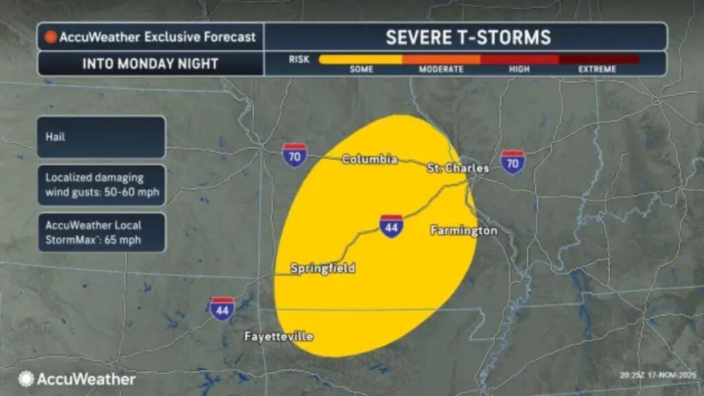
South of the wintry corridor, warm, moist air will fuel thunderstorms, starting Monday night in southern Missouri and northern Arkansas. By Tuesday, storms are expected to sweep across the Ohio Valley, potentially producing strong wind gusts, hail, and isolated tornadoes.
By Wednesday, the storm is expected to move off the mid-Atlantic coast, where temperatures will generally be too warm for snow.
Prepare for Mixed Conditions
Officials and meteorologists urge residents in the affected regions to:
- Drive cautiously on bridges, overpasses, and elevated surfaces.
- Monitor local forecasts for sudden changes in snowfall or severe weather warnings.
- Be ready for severe thunderstorms, especially in the southern part of the storm track, where isolated tornadoes are possible.
This storm serves as a reminder that rapidly moving systems can create both winter hazards in the north and severe weather in the south, requiring vigilance across multiple states.
Have you experienced snow, slush, or storm-related issues in your area? Share your updates and tips in the comments below to help the community stay safe.


