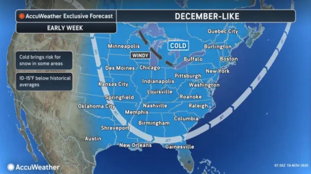
TRENTON, N.J. — Bundle up, New Jersey — an arctic blast is sweeping through the state, bringing the coldest air mass of the season and wind chills that could dip into the teens by Monday night, according to the National Weather Service (NWS).
Cold Front Ushers in Bitter Temperatures
A strong cold front moved through the region Monday evening, setting the stage for a sharp temperature drop overnight. After a mild afternoon with highs in the upper 40s to mid-50s, temperatures are expected to plummet into the upper 20s and low 30s by early Tuesday.
“Add in the wind and minimum wind chill values will crater into the upper-teens to low-20s,” the NWS Mount Holly office said in its latest update.
Wind Gusts and Falling Temperatures
Throughout Monday, parts of eastern New Jersey experienced lingering morning fog before the cold front passed, accompanied by light rain showers. By late afternoon, west-northwest winds began to strengthen, with gusts between 20 and 30 mph.
The chilly winds will intensify into Tuesday, with gusts potentially reaching 30 to 35 mph, keeping conditions brisk and uncomfortable.
Even with sunny skies, the deep cold air mass will hold daytime highs in the low to mid-40s, while wind chills are expected to start in the teens early Tuesday and only rise into the low 30s by afternoon.
Midweek Warming Trend
Relief is on the horizon, though gradual. By Wednesday, southwesterly winds will usher in a modest warming trend, bringing highs back into the upper 40s and mid-50s under partly sunny skies.
However, the breezy conditions will persist, with gusts around 20 to 25 mph expected. A weak cold front may sweep across the state late Wednesday, but forecasters say precipitation is unlikely, keeping the region mostly dry.
End of the Week: Dry and Slightly Milder
From Thursday through the weekend, mostly dry conditions are forecast, with temperatures running a few degrees below normal for mid-November.
Expect highs in the upper 40s to low 50s on Thursday and Friday, gradually moderating into the 50s over the weekend.
The next storm system may approach Sunday afternoon or evening, potentially bringing rain back to parts of the Garden State.
What Residents Should Know
Officials urge residents to dress in layers, limit time outdoors, and take precautions for pets and plants as temperatures plunge. The cold snap marks the first significant test of winter preparedness for much of New Jersey, especially following a relatively mild start to November.
Drivers are also advised to be cautious during the early morning commute, as patchy frost could form on untreated surfaces.
How are you preparing for New Jersey’s first arctic blast of the season? Share your thoughts and cold-weather tips in the comments — and let us know how the freezing temperatures are affecting your area!