Kansas City, MO – Residents across parts of the Midwest and South are being urged to stay alert this weekend as severe weather threatens to bring tornadoes, hail, strong winds, and flash flooding. Meteorologists warn that a cold front moving across a warm and humid atmosphere could trigger dangerous storms from Texas all the way to Ohio.
Authorities and weather agencies emphasize that the risk of severe storms is significant, especially in areas that have experienced recent drought conditions. Communities are advised to monitor local alerts and take necessary precautions to stay safe.
Friday Night: Storms Begin Across Central States
Starting Friday night, strong storms are expected to develop in a line stretching from Oklahoma to Missouri, moving through Kansas. The line of storms is projected to intensify after 10 p.m. CST and will progress eastward overnight, setting the stage for a severe weather weekend.
Potential hazards include:
- Tornadoes capable of causing property damage
- Large hail that can damage vehicles and crops
- Damaging winds exceeding 50 mph
- Flash flooding from intense rainfall
Residents in the path of these storms are urged to secure outdoor objects, avoid travel during severe weather, and remain indoors whenever warnings are in effect.
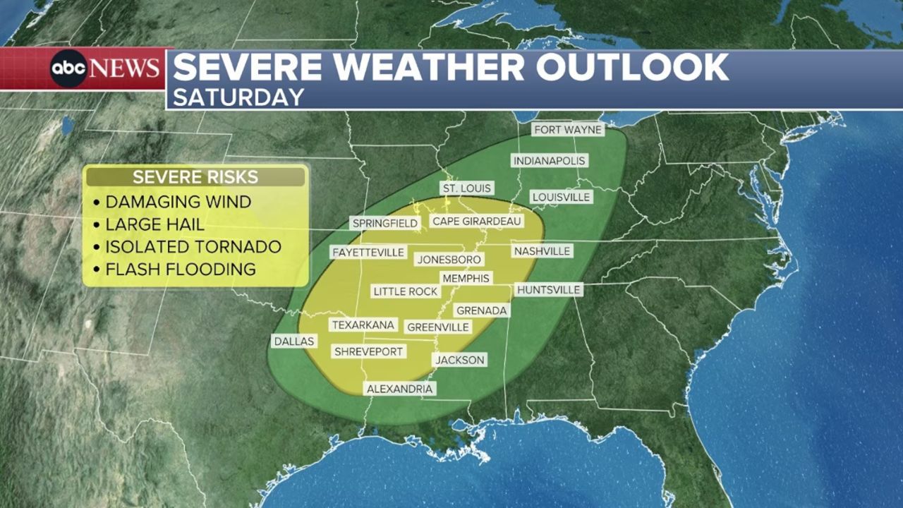
Saturday: Severe Weather Threat Peaks
On Saturday, the severe weather threat expands from Ohio to Texas, starting around 8 a.m. local time and continuing through the afternoon. As per ABC News, the cities most at risk include:
- St. Louis, Missouri
- Dallas, Texas
- Nashville, Tennessee
While these regions have experienced drought over the past two months, rainfall totals could range from 1 to 2 inches, with some areas receiving excessive rain in a short period, raising the risk of flash flooding.
Meteorologists advise residents to stay tuned to local weather reports, especially if traveling or attending outdoor events, as conditions may change rapidly.
Sunday: Storms Move East
By Sunday, the storm system will continue its eastward track, bringing rain and potential strong winds to Ohio, West Virginia, Pennsylvania, and western New York. While the intensity of severe weather is expected to decrease, isolated storms could still produce large hail and gusty winds.
The Northeast will see rainfall reaching the region on Sunday night, continuing into Monday, potentially affecting morning commutes and the start of the work and school week.
Safety Tips for Severe Weather
- Monitor weather alerts through trusted sources such as the National Weather Service.
- Have an emergency kit ready, including water, non-perishable food, flashlight, and first-aid supplies.
- Avoid flooded roads; even shallow water can sweep vehicles away.
- Stay indoors during tornado or severe thunderstorm warnings and away from windows.
- Plan outdoor activities carefully, as storms can develop quickly with little notice.
With unpredictable conditions across a wide region, residents are urged to remain vigilant and follow all safety recommendations. Being prepared could make a critical difference during this weekend’s severe weather events.
How is your area preparing for this severe weather? Share your safety tips and experiences in the comments below!


