Rodanthe, NC – Hurricane Erin slammed North Carolina’s Outer Banks with strong winds, high waves, and coastal flooding, forcing the closure of key highways and putting beachfront homes at risk as the storm moved up the East Coast.
Storm Conditions and Forecast
Forecasters with the National Hurricane Center (NHC) in Miami said Erin could regain strength and potentially become a major hurricane (Category 3 or greater), though it is not expected to make landfall along the East Coast before veering out to sea. Tropical storm conditions were anticipated along parts of the Outer Banks and the Virginia coast, while Bermuda residents were warned to stay out of rough seas through Friday.
Impact on Outer Banks
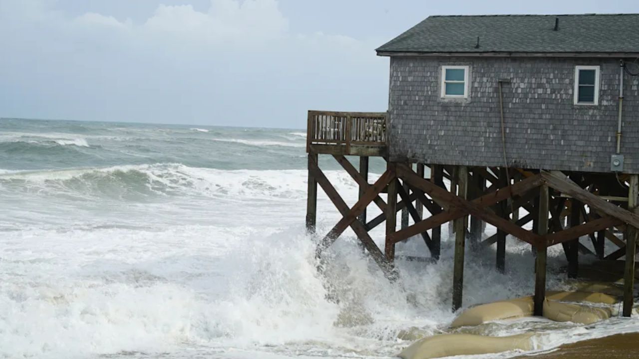
As Erin’s outer bands hit the Outer Banks, water surged onto Highway 12, the main route connecting the barrier islands. Several stilted homes perched above the beach faced flooding. Ocracoke Island’s ferry terminal was cut off, and officials warned that high tides combined with massive waves could temporarily isolate villages and homes.
Authorities also warned of life-threatening rip currents from Florida to New England, prompting beach closures in New York City, New Jersey, Maryland, and Delaware. Nantucket Island in Massachusetts could see waves exceeding 10 feet (3 meters) later in the week.
Community Reactions
Despite the warnings, some residents appeared unconcerned. Jacob Throne, a Hatteras Island resident, said:
“I remember taking canoes out of my front yard to get to school, so I don’t think it’s gonna be that bad.”
However, rescues continued as swimmers ignored the closures. More than a dozen people were saved from rip currents at Wrightsville Beach, NC, just a day after over 80 rescues as per reports.
Expert Warnings
Bob Oravec, a National Weather Service forecaster, emphasized the dangers:
“You can be aware all you want. It can still be dangerous.”
State officials warned that 20-foot (6.1-meter) waves and fierce winds could cause coastal flooding in many beachfront communities. Will Ray, North Carolina’s emergency management director, said:
“Dangerous conditions can be felt far from the eye, especially with a system as large as Erin.”
David Hallac, superintendent of the Cape Hatteras National Seashore, added that beach homes already weakened by erosion could be particularly vulnerable.
Storm Size and Movement
Hurricane Erin has become an unusually large and potentially dangerous system, with tropical storm-force winds spreading across 500 miles (800 kilometers) — roughly the distance from New York City to Pittsburgh. As of early Thursday, Erin remained a Category 2 hurricane with maximum sustained winds of 105 mph (165 kph), located about 200 miles (320 km) southeast of Cape Hatteras, moving north-northeast at 17 mph (28 kph).
Safety Recommendations
Authorities urge residents and visitors in the Outer Banks and along the East Coast to:
- Avoid swimming or entering the water during the storm.
- Secure property and evacuate if ordered by local officials.
- Monitor local weather updates and follow instructions from emergency management agencies.
Conclusion
Hurricane Erin demonstrates the serious risks of coastal storms, including flooding, dangerous rip currents, and property damage. Residents are advised to remain vigilant as the storm progresses and to prioritize safety over convenience.
Have you prepared your home or family for Hurricane Erin? Share your safety tips in the comments below.


