Los Angeles, CA – Residents living near recent wildfire burn scar zones across Southern California are facing evacuation orders, flood watches, and heightened safety warnings as a powerful holiday storm moves into the region. Officials say the incoming weather system poses a serious threat of flash flooding, mudslides, and debris flows, particularly in areas still vulnerable from past fires.
Authorities are urging residents to take evacuation notices seriously as the storm intensifies through Christmas Eve and Christmas Day.
Evacuation Orders Issued for High-Risk Burn Scar Areas
According to the Los Angeles Emergency Management Department, flood watches and evacuation warnings went into effect at 11 a.m. Tuesday and are expected to remain active until 11 p.m. Thursday for much of the Palisades, Sunset, and Hurst burn scar zones.
Law enforcement officers and emergency personnel have been going door to door to notify residents in especially vulnerable locations. Officials confirmed that evacuation orders, not just warnings, are in place for dozens of addresses.
“Currently, the Los Angeles County Sheriff’s Department has a total of 124 evacuation orders in place,” said Sheriff Robert Luna during a Tuesday morning news conference. “All properties were door-knocked, and those that didn’t answer were given a door hanger.”
Luna emphasized that refusing to evacuate could have deadly consequences. “These evacuation orders are made with your safety in mind,” he said, warning that those who stay behind are placing their own lives and their families’ lives at risk.
Additional Warnings Issued Near Eaton Fire Burn Scar
Evacuation warnings have also been expanded to portions of the Eaton Fire burn scar areas, where steep terrain and unstable soil increase the risk of debris flows.
Officials encouraged residents to review the interactive Los Angeles County evacuation map to determine whether their homes are impacted and to stay alert for updates as conditions change.
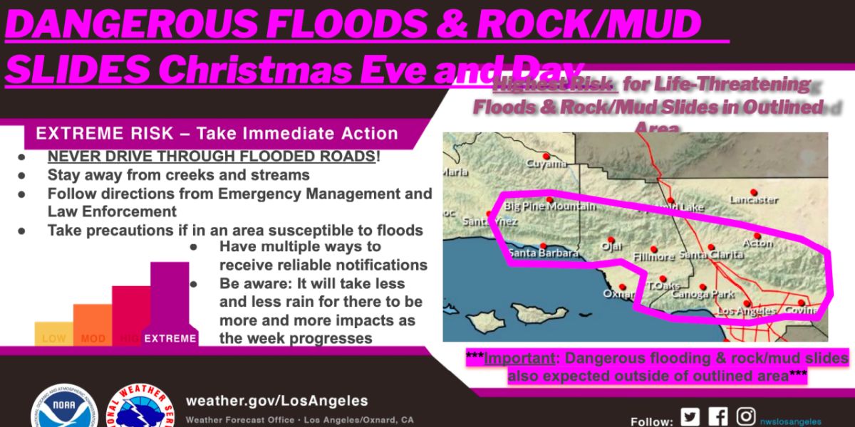
Atmospheric River Brings Extreme Flood Risk
The National Weather Service (NWS) is forecasting an extreme risk of dangerous flooding and debris flows from Tuesday through Saturday night, with the most hazardous conditions expected on Christmas Eve and Christmas Day.
“This is a warm winter storm event,” said Mark Pestrella, Director of Los Angeles County Public Works. “Some call it the Pineapple Express; others call it an atmospheric river—and that’s accurate.”
Pestrella warned that the storm could dump a significant amount of rain in a short time. “We expect heavy rainfall with intensities that give us concern,” he said, adding that the region has not experienced an atmospheric river of this magnitude in three to four years.
Rainfall Totals and Timing
According to the NWS, coastal and valley areas south of Point Conception could receive between 3 and 6 inches of rain, while mountains and foothills may see up to 11 inches through Christmas Day.
The heaviest rainfall is expected late Tuesday night into Wednesday, with another intense round possible Wednesday night into Thursday.
City and County Prepare for Debris Flows
In preparation for potential debris flows following January wildfires, officials have positioned more than 13,000 feet of K-rail barriers in Pacific Palisades and implemented additional flood mitigation measures throughout high-risk zones.
“Los Angeles City personnel continue preparing for the storm this holiday week,” said Mayor Karen Bass. “First responders, public works crews, and utility personnel are ready to respond to potential impacts.”
Bass urged residents planning holiday travel to exercise caution and remain informed, encouraging people to sign up for alerts at NotifyLA.org.
Officials are urging residents to prepare now, before the heaviest rain arrives.
Warm Storm, Snow Arrives Christmas Day
Despite the heavy rain, temperatures will remain relatively warm for December, keeping snow levels above 7,500 to 8,000 feet through Christmas Eve. Snow levels are expected to drop to around 7,000 feet on Christmas Day, bringing accumulating snowfall to mountain resort areas.
Officials say no winter travel impacts are expected before Christmas, but hazardous conditions may develop afterward.
Are you or your family affected by the evacuation orders or flood warnings? Do you feel prepared for the incoming storm? Share your thoughts, experiences, and safety tips in the comments below and help keep your community informed.


